[KM35] Soil water erosion

Key message

Soil erosion is a natural geomorphic process of soil particle detachment and transport. Due to human activities, it can be significantly accelerated, reaching levels much higher than in natural conditions. Erosion (water, wind, and tillage erosion) remains the most significant threat to soils in many regions of the world. Measuring erosion is typically done under controlled conditions on standardized test plots, which is a time-consuming, costly, and organizationally demanding process. Therefore, erosion risks and intensities are often assessed using computational models.
Global and regional estimates of erosion vary widely depending on the methodology used. General estimates of average soil erosion on arable land are significantly higher (ranging from 8 to almost 50 tons per hectare per year) than estimates from regional and global models (ranging from 2 to 4 tons per hectare per year). Each erosion estimate should be evaluated against an acceptable level of soil loss.
Definition
The index addresses water erosion on agricultural lands. The occurrence and intensity of soil erosion largely depend on the occurrence, intensity and amount of precipitation, topography, soil type and characteristics, slope length and gradient, agricultural practices, and potential anti-erosion protective measures.
It is expected that the annual average erosion rate varies according to the occurrence, intensity and force of precipitation in the given year, changes in land cover, the type of agricultural practices on individual plots, and implemented anti-erosion measures.
Charts
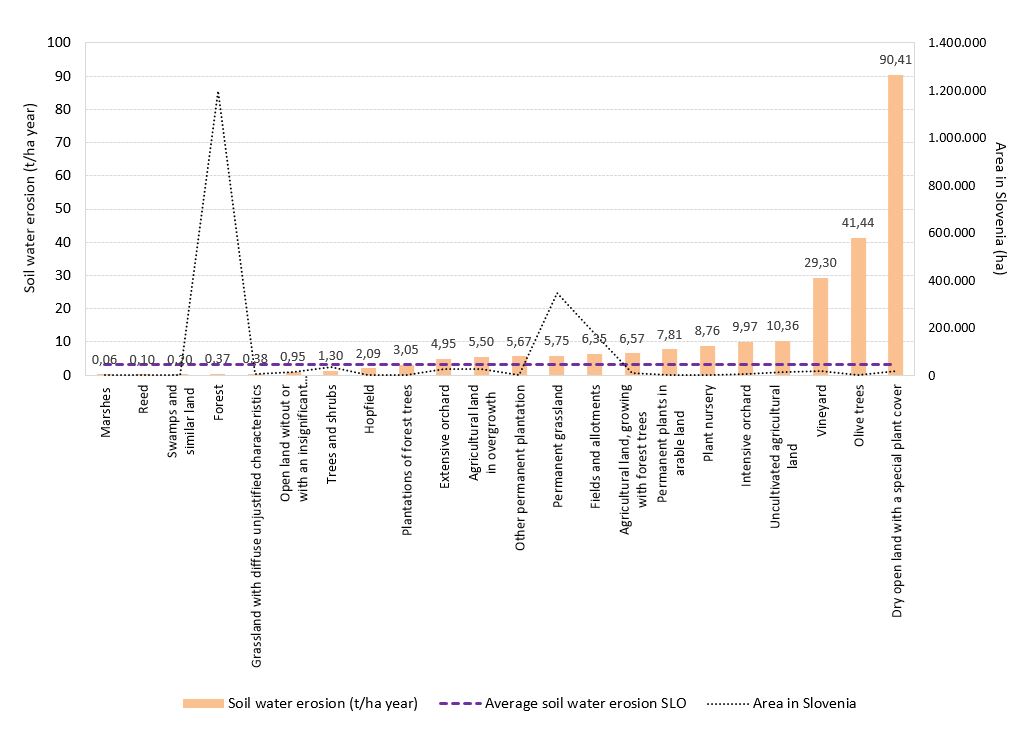
AIS, 2020; MAFF, 2020
| Soil water erosion (t/ha year)[t/ha] | Average soil water erosion SLO[t/ha] | Area in Slovenia[ha] | |
|---|---|---|---|
| Marshes | 0.06 | 3.18 | 42 |
| Reed | 0.10 | 3.18 | 66 |
| Swamps and similar land | 0.20 | 3.18 | 1204 |
| Forest | 0.37 | 3.18 | 1197504 |
| Grassland with diffuse unjustified characteristics | 0.38 | 3.18 | 5576 |
| Open land witout orwith an insignificant plant cover | 0.95 | 3.18 | 12514 |
| Trees and shrubs | 1.30 | 3.18 | 33823 |
| Hopfield | 2.09 | 3.18 | 1898 |
| Plantations of forest trees | 3.05 | 3.18 | 256 |
| Extensive orchard | 4.95 | 3.18 | 28088 |
| Agricultural landin overgrowth | 5.50 | 3.18 | 24555 |
| Other permanent plantation | 5.67 | 3.18 | 455 |
| Permanent grassland | 5.75 | 3.18 | 347272 |
| Fields and allotments | 6.35 | 3.18 | 179033 |
| Agricultural land, growingwith forest trees | 6.57 | 3.18 | 10769 |
| Permanent plants inarable land | 7.81 | 3.18 | 346 |
| Plant nursery | 8.76 | 3.18 | 45 |
| Intensive orchard | 9.97 | 3.18 | 4379 |
| Uncultivated agriculturalland | 10.36 | 3.18 | 14341 |
| Vineyard | 29.30 | 3.18 | 17861 |
| Olive trees | 41.44 | 3.18 | 2403 |
| Dry open land with a special plant cover | 90.41 | 3.18 | 17950 |
Goals
- Reducing water erosion, especially on agricultural but also on other lands.
- Ensuring sustainable food production and food safety while minimizing soil water erosion.
Comment
Assessing Erosion in Slovenia using More Accurate Data
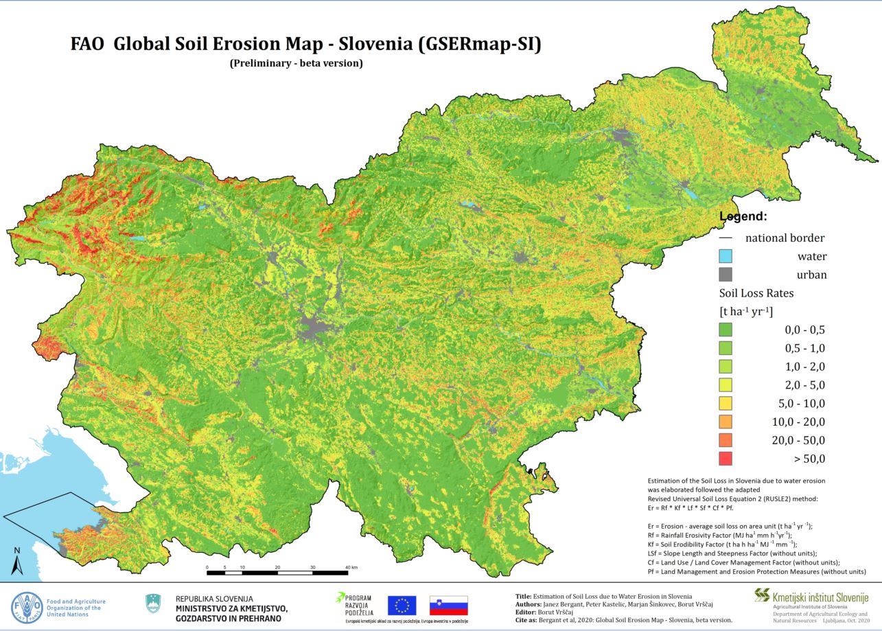
The RUSLE method reliably estimates erosion intensity on slopes of less than 50% (< 26.6°). However, the estimates for steeper slopes are less reliable but still informative. Regarding the land use categories, erosion is most pronounced in permanent crops (average of 15.2 t/ha), on lands with intensive soil cultivation, such as fields and gardens (6.4 t/ha), while the overall erosion on all types of grassland is slightly lower (5.7 t/ha). Calculations for each type of land use show that erosion is most prominent in lands with exposed and tilled soil. The highest erosion occurs in olive groves (41.4 t/ha) and vineyards (29.3 t/ha), while it's somewhat lower in intensive orchards (10.0 t/ha) and even lower in arable lands (6.4 t/ha). For olive groves and vineyards, and to a lesser extent for intensive orchards, it is estimated that the RUSLE calculations may be overestimated because a significant portion of these agricultural crops are on terraces. Terraces were not considered in the calculations because there is not enough precise data on terrace usage in Slovenia. Similarly, precise data on grass cover in permanent crops could reduce erosion estimates for these land uses.
For permanent grasslands, erosion is estimated to be relatively high (5.8 t/ha), which is understandable due to the higher proportion of steep slopes in these areas. As expected, erosion rates in forests are significantly lower. Erosion in forests across Slovenia is estimated to be considerably higher (0.37 t/ha) than in forests on slopes with gradients of less than 50% and in flat areas (0.25 t/ha). The prohibition of clear-cutting also contributes to the low erosion estimates.
The average annual erosion in Slovenia is estimated at 3.2 t/ha. For 82.9% of the Slovenian territory on flatlands and slopes with gradients of less than 50%, it is estimated at 2.6 t/ha. A very high percentage of forests (59%) contributes to the relatively low erosion estimate for the entire country.
The results of erosion intensity modeling using more accurate data significantly differ from rough estimates suitable for a continental scale.
Erosion Assessment within Europe
Within the EC Joint Research Centre (JRC), the European Soil Data Centre (ESDAC) conducted erosion modeling and published an extensive erosion assessment for most EU countries or a significant part of the continent in 2015 (Panagos et al., 2015). The results of this erosion modeling indicate that Slovenia ranks second among EU member states in terms of annual erosion, with an average of 7.43 t/ha/year of eroded soil in all land uses. They explain that Slovenia's high erosion rate is due to the intense erosivity of rainfall and steep topography. Italy has a higher average annual erosion rate (8.46 t/ha), while Austria ranks third with 7.19 t/ha. For arable land in Slovenia, it is estimated to 4.63 t/ha per year. The Primorsko-Notranjska, SE Slovenia, and Savinjska statistical regions have an average annual erosion rate of 10 – 20 t/ha, again among the highest in the EU; the western part of Slovenia, along with the Osrednjeslovenska region, ranges from 5 – 10 t/ha; Posavska, Podravska, and Pomurska regions are between 2 – 5 t/ha.
These figures significantly exceed the estimates and general opinion of erosion intensity in Slovenia.
Methodology
- Bergant, J., Kastelic, P., Šinkovec, M., Vrščaj, B., 2020. Izdelava karte erozije RS na kmetijskih tleh. Projektna naloga. Ljubljana: Kmetijski inštitut Slovenije. Https://www.kis.si/Zbirka_vseh_projektov_OKENV/Izdelava_karte_erozije_RS_na_kme…. Citirano 25.10.2023
- Desmet P.J.J., Govers G., 1996. A GIS procedure for auto¬matically calculating the USLE LS factor on topographi¬cally complex landscape units. Journal of Soil and Water Conservation, 51: 427–433.
- Foster G.R., Wischmeier W.H., 1974. Evaluating irregular slopes for soil loss prediction. Trans. ASAE 17, 305-309.
- Foster, G. R., Toy, T. E., and Renard, K. G., 2003. Comparison of the USLE, RUSLE1.06c, and RUSLE2 for Application to Highly Disturbed Lands, in: First Interagency Conference on Research in Watersheds, 27–30 October, 154–160, United States Department of Agriculture.
- JRC, ESDAC, Cover Management Factor (online) URL: https://esdac.jrc.ec.europa.eu/themes/cover-management-factor. Citirano 4.3.2020.
- Lal, R, Elliot, W., 1994. Erodibility and Erosivity. In R. Lal , ed. Soil erosion research methods. Second Edition. Pp. 181-210. Soil and Water Conservation Society and St. Lucie Press, Florida, USA.
- Moore I.D., Wilson J.P., 1992. Length-slope factors for the Revised Universal Soil Loss Equation: Simplified method of estimation. Journal of Soil and Water Conservation, 47: 423–428.
- NRCS (2014) National Soil Erosion Results Tables | NRCS. http://www.nrcs.usda.gov/wps/portal/nrcs/detail/national/technical/?cid…. Accessed 12 Oct 2014
- Panagos P., Borelli P., Meusburger K., 2015c. A New European Slope Length and Steepness Factor (LS Factor) for Modeling Soil Erosion by Water. Geosciences 2015, 5, 117-126.
- Panagos, P., Borelli, P., Meusburger, C., Alewell, C., Lugato, E., Montanarella, L., 2015b. Estimating the soil erosion cover-management factor at European scale. Land Use Policy, 48 C (2015), str 38 - 50. (online) URL: https://www.sciencedirect.com/science/article/pii/S0264837715001611
- Panagos, P., Borrelli, P., Poesen, J., Ballabio, C., Lugato, E., Meusburger, K., Montanarella, L., Alewell, C., 2015a. The new assessment of soil loss by water erosion in Europe. Environmental Science & Policy 54, 438–447. https://doi.org/10.1016/j.envsci.2015.08.012.
- Petan S., 2010. Meritve in prostorsko modeliranje erozivnosti padavin kot parametra erozije tal. Doktorska disertacija. UL, FGG, Oddelek za okoljsko gradbeništvo, Ljubljana: 205 p.
- Renard K.G., 1997. Predicting Soil Erosion by Water : A Guide to Conservation Planning with the Revised Universal Soil Loss Equation (RUSLE). Washington, D.C., USDA, Agricultural Research Service.
- Renard, K. and Freimund, J. R., 1994. Using monthy precipitation data to estimate R-factor in the revised USLE, J. Hydrol., 157, 287–306.
- Resolucija o Nacionalnem programu varstva okolja za obdobje 2020–2030 (ReNPVO20–30). http://www.pisrs.si/Pis.web/pregledPredpisa?id=ODLO1985
- RUSLE online soil erosion assessment tool (online) URL: http://www.iwr.msu.edu/rusle/. Citirano: 4.3.2020.
- USDA, 1997. Prediciting Soil Erosion by Water: A guide to Conservation Planning With the Revised Universal Soil Loss Equation (RUSLE). USDA ; Agricultural Research Service
- USDA, 2001. Revised Universal Soil-loss Equation Version 2 (RUSLE2 ) Handbook. USDA RUSLE Development Team
- Van der Knijff J.M., Jones, R.J.A., Montanarella, L., 2000. Soil Erosion Risk Assessment in Europe. JRC - Joint Research Centre, European Soil Bureau, Evropska komisija, 2000. 34 str.
- Wischmeier W.H., Smith D.D., 1965. Predicting Rainfall – Erosion Losses from Cropland East of the Rocky Moun¬tains: Guide for Selection of Practices for Soil and Water Conservation. Washington, D.C., USDA, Agricultural Research Service.
- Zorn M., Komac B., 2009. Response of soil erosion to land use change with particular re-ference to the last 200 years (Julian Alps, Western Slovenia). Revista de geomorfologie, 11: 39-47.
- Zorn M., Mikoš, M., 2009. Erozija tal v slovenski Istri = Soil erosion in Slovene Istria. Geologija 52/2, 221-232.


