[GZ04] Forest area

Key message

Forest area is relatively easy to measure. It is one of the basic indicators used in monitoring the development of forests.
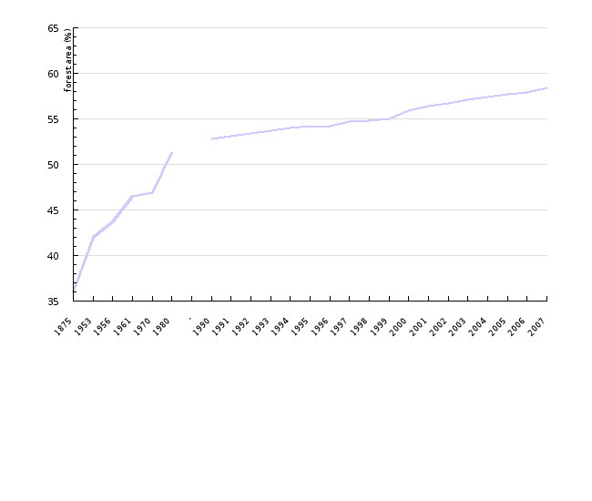
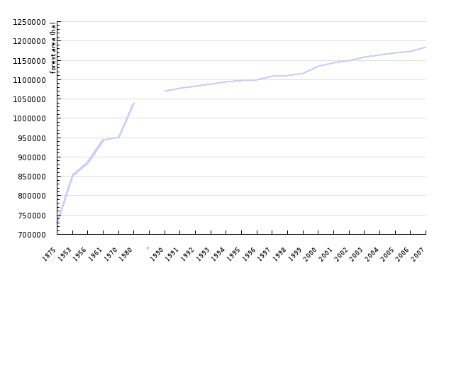
In the last centuries, the forest area has been increasing. Our data reach back to 1875 when forests covered only 36% of the territory. According to the report of the Slovenia Forest Service, the forest area in 2007 was 1,183,252 ha. Nowadays, 58.4% of the Slovenian territory is covered in forests.
The distribution and changes of forest surfaces are also monitored by the Ministry of Agriculture, Forestry and Food within the framework of the project Tracking and Monitoring the Use of Agricultural Land.
The legal basis is described in detail in the Agriculture Act (Articles 101 and 107). The Slovenia Forest Service participates by checking the forest border. According to this data, the forest area in 2005 took up 1,213,423.85 ha, which was almost 60% of the entire Slovenian territory.
Definition
In the Act on Forests, a forest is defined as land containing forest trees in the form of a stand or other woodland fulfilling any of the functions of a forest. According to this act, any areas reverting to natural vegetation that have been classified as a forest in the spatial part of the Forest Management Plan are considered as forests.
In the FAO Global Forest Assessment 2005 (TBFRA) the following definitions are listed:
Forest: Land with tree crown cover (or equivalent stocking level) of more than 10 percent and area of more than 0.5 ha. The trees should be able to reach a minimum height of 5 m at maturity in situ. Young natural stands and plantations established for forestry purposes and areas normally forming part of the forest area which are temporarily unstocked as a result of human intervention or natural causes are also included. This definition also includes forest nurseries and seed orchards that constitute an integral part of the forest, forest roads, firebreaks, etc.
EUROSTAT defines the forest as follows:
Forest: A forest area is made up of forest and other wooded land. Forest is defined as land with tree crown cover of more than 20% of the area. Forest is continuous and the trees reach a minimum height of 7 m and are able to produce wood. Other wooded land is defined as area that has some characteristics of forest, but does not belong to the above definition. It includes open woodland and shrubs and may or may not be used for pasture. The manner of determining the forest area is defined by the Regulation on the forest management and silviculture plans.
Charts
Slovenia Forest Service, 2008.
| 1875 | 1953 | 1956 | 1961 | 1970 | 1980 | - | 1990 | 1991 | 1992 | ||
|---|---|---|---|---|---|---|---|---|---|---|---|
| share of forest | % | 36 | 42 | 43.7 | 46.5 | 46.9 | 51.3 | 52.8 | 53.1 | 53.4 | |
| 1993 | 1994 | 1995 | 1996 | 1997 | 1998 | 1999 | 2000 | 2001 | 2002 | ||
| share of forest | % | 53.7 | 54 | 54.2 | 54.2 | 54.7 | 54.8 | 55 | 55.9 | 56.4 | 56.7 |
| 2003 | 2004 | 2005 | 2006 | 2007 | |||||||
| share of forest | % | 57.1 | 57.4 | 57.7 | 57.9 | 58.4 |
Slovenia Forest Service, 2008.
| 1875 | 1953 | 1956 | 1961 | 1970 | 1980 | - | 1990 | 1991 | 1992 | ||
|---|---|---|---|---|---|---|---|---|---|---|---|
| forest area | hectare | 729717 | 852147 | 885501 | 943209 | 951484 | 1039626 | 1071151 | 1076914 | 1082676 | |
| 1993 | 1994 | 1995 | 1996 | 1997 | 1998 | 1999 | 2000 | 2001 | 2002 | ||
| forest area | hectare | 1088439 | 1094201 | 1097929 | 1098844 | 1109710 | 1111006 | 1115661 | 1134227 | 1142869 | 1149633 |
| 2003 | 2004 | 2005 | 2006 | 2007 | |||||||
| forest area | hectare | 1157824 | 1163812 | 1169196 | 1173847 | 1183252 |
Goals
The Forest Development Programme assumes that the percentage of forests shall not increase significantly in the future. In the draft National Forest Programme, the basic findings with regard to the development of forest areas are described, the most important one being that forest areas are increasing in places where there are sufficient forests from the viewpoint of landscape variety and appearance; however, despite the forest preservation efforts, a lot of pressure is exerted on the forests in the areas with intensive agriculture and especially in suburban areas, gradually leading to deforestation of areas that already lack forests. That is why it is important to stop these two conflicting processes. As for the forest area itself, it shall probably remain stagnant at about 60%.
Comment
Forest area is relatively easy to measure, which is why we already have extensive information reaching back to 1875 when forests represented only 36% of the territory. Since then (for more than 130 years), the forest area has been increasing constantly. Despite this trend, however, we cannot be satisfied with the distribution of forest areas.
According to the FAO Global Forest Assessment, Slovenia has a large percentage of forests in comparison with the rest of Europe; however, the absolute percentage is much lower. The total surface area of forests in Europe (including Russia) in 2005 was 192,604 ha (1,001,393,000 ha), which is 44.3% of the entire territory. In the period between 2000 and 2005, the surface area of forests has increased by 756,000 ha (661,000 ha), or 0.40% (0.07%).
Similar trends have been noted in the past decades on the European scale. A large share of afforestation was performed immediately after World War II, and this trend has settled in the last decades. Areas appropriate for afforestation are shrinking and the cost of this type of work is increasing. The share of managed forests is increasing at an even slower rate, as a result of the growing number of protected areas.
Assessment of the trend:
The assessment of the trend in Europe for the coming decades (TBFRA 2005) is that forest area will continue to grow moderately. A similar assessment has also been made for Slovenia. A more detailed review was presented in Section 4 (Goal(s)), where our expectations regarding the movement of forest area were defined. We expect the indicator to develop towards reaching the set objective.
Methodology
How was the indicator measured?
The data on forest area were acquired from annual reports of the Slovenia Forest Service (since 1994) and archived data. Reports are made based on 10-year Forest Unit Management Plans that are updated at regular (most often 10-year) intervals.
The manner of determining the forest area is defined in the Rules on the forest management and silviculture plans. According to Article 2 of the Act on Forests, forest area is determined by projecting relevant images acquired by means of remote sensing onto base topographical maps that can be checked on the spot if necessary. Forest also includes agricultural land reverting to natural vegetation if it has not been used for agricultural purposes for over 20 years and if the crown cover exceeds 75%. Areas larger than 0.5 ha are treated in 0.5 ha segments. The forest border is entered onto the base topographical map (scale 1:5,000 or 1:10,000), representing the documentation material accompanying the plan. At specific segments and at higher levels, the forest areas are determined to the nearest 0.01 ha. Forest area at specific plots is determined by comparing maps of the forest area and plots and is checked on the spot if necessary.
Data for Slovenia:
• name of the original database: Annual reports of the Slovenian Forest Service,
• institution acting as the administrator of the database: Slovenian Forestry Institute,
• description of the data source: Annual reports of the Slovenian Forest Service on forests,
• data are shown for the period: 1875 – 2007.
Data for Europe:
• name of the original database: Global Forest Assessment 2005, Global Forest Assessment 2000,
• institution acting as the administrator of the database: UN FAO, Department of Forestry,
• description of the data source: Data and analyses in the report were calculated based on reports from individual countries.
Sources:
o Slovenia Forest Service, Central Database of Forest Management Unit Plans, 2008.
o Slovenian National Forest Development Programme , Official Gazette of the Republic of Slovenia, no. 14/1996 of 8-3-1996.
o National Forest Programme, Draft. March 2007,
o Rules on the forest management and silviculture plans, Official Gazette of the Republic of Slovenia, no. 5/1998 of 23-1-1998, pp. 256 – 282.
o Rules amending the Rules on forest management and silviculture plans, Official Gazette of the Republic of Slovenia, no. 70/2006 of 6-7-2006, pp. 7293-7298.
o National Environmental Action Plan (NEAP), Official Gazette of the Republic of Slovenia, no.. 83-3953/1999, p. 12765.
o Global Forest Resources Assessment 2005, UN FAO, Department of Forestry, 2006.
o Global Forest Resources Assessment 2000, UN FAO, Department of Forestry, 2001.


