[TP01] Land cover and land use

Key message

-
Definition
The indicator shows the characteristics of land use and land cover, as well as their change between 1996, 2000 and 2006, applying CORINE Land Cover methodology.
Dominating processes of land cover changes or different types of flows between land cover types are presented using the LEAC (Land and Ecosystems accounts) methodology.
Charts
CORINE Land Cover 2006, Ministry of the Environment, Spatial Planning and Energy, Environmental Agency of the Republic of Slovenia, Surveying and Mapping Authority of the Republic of Slovenia, European Environment Agency, 2007
CORINE Land Cover 2000 and 2006, Ministry of the Environment, Spatial Planning and Energy, Environmental Agency of the Republic of Slovenia, Surveying and Mapping Authority of the Republic of Slovenia, European Environment Agency, 2007
CORINE Land Cover 2000 and 2006, Ministry of the Environment, Spatial Planning and Energy, Environmental Agency of the Republic of Slovenia, Surveying and Mapping Authority of the Republic of Slovenia, European Environment Agency, 2003 and 2007; calculations Environmental Agency of the Republic of Slovenia, 2008
Goals
Sustainable use of natural resources.
Inclusion of individual components of environmental protection in the planning of sustainable spatial development:
• economic and multi-purpose use of land and resources,
• rational use of land for urbanisation and controlled expansion of urbanised areas,
• preservation of production potential of land for agricultural use and balanced supply of mineral resources.
Comment
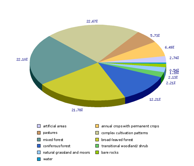
More than half of land area of Slovenia is covered by forests (56 %), including shrub 58 %), other dominantly natural vegetation (natural grassland and moors, water areas, bare rocks) cover 4 % of land, 35 % of land is dedicated predominantly to agriculture, and less than 3 % are artificial areas. This is the picture of land cover as presented by interpretation of satellite image, taken in 2006, using CORINE Land Cover methodology (CLC 2006).
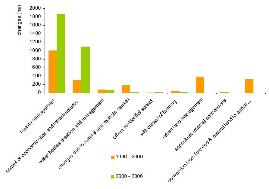
The same methodology was applied in 2000 (CLC2000) and 1996 (CLC95), so an analysis of changes is possible. These are relatively small and in none of the periods covered do they represent more than around 0.1 % of the entire territory. Account needs to be taken of the fact that the methodology used only covers land cover changes greater than 5 ha. There are more artificial areas: between 1996 and 2006 road infrastructure areas increased by 603 ha, and the majority of larger construction sites opened after 2000 (507 ha) is dedicated for new roads as well. There are at least for 86 ha more commercial and industrial areas.
A decrease in the number of household members and thus increased demand for housing areas per person is a phenomenon which is evident in a significant increase of he housing areas in the majority of European countries. Notwithstanding in Slovenia only very small increase of residential areas was detected (11 ha between 1996 and 2000 and 12 ha between 2000 and 2006). Partly such observations can be attributed to the introduction of the measures in spatial planning which promoted construction of housing units mostly inside urban areas. On the the hand the dispersed settlement structure where a half of the population lives in small settlements with fewer than 2,000 inhabitants can denote a number of small changes that are not detected by the CORINE Land Cover methodology.
Analysis of the course of changes (Figure 2) between individual types of land cover and use (LEAC) has shown that the biggest changes took place in forest areas. Between 1996 and 2000, around 520 ha of forest land was felled and reforested, mainly in deciduous forests, and between 2000 and 2006 this was done over 1 700 ha of mainly evergreen forests. Areas of transitional woodland scrub identified by the methodology occupied 150 ha. The shrinking of forests was also necessary for the construction of infrastructure.
Forests with transitional woodland shrub constitute the prevailing land cover category in Slovenia, but they are not evenly distributed. The largest dense forest areas cover the Dinaric-Karst plateaus of the southern and south-western Slovenia and Alpine slopes on north and west.
In the framework of Slovenia's natural conditions the variegated interweaving of forest and agricultural areas may be considered a quality landscape. Such areas, classified as “Mixed farmland” and “complex cultivation patterns” cover 14 % and 9 % area,, a quarter of total Slovenia land area. From the economic aspect of agricultural production, breaking down agricultural areas is not a desirable process, but from the aspect of the cultural landscape, it is the diversity of landscape patterns and interweaving of different types of use that provides a richer biodiversity, important natural and cultural heritage and is part of Slovenian identity. “Arable land” category covers 112.237 ha, vineyards 15.723 ha and other permanent plantations 3.627 ha, together approximately 6,5 % of land area. In the 1996 – 2000 period, agricultural areas recorded an increase in the surface area of pastures, while the non-irrigated arable land, complex cultivation patterns, and the category of land principally occupied by agriculture with significant areas of natural vegetation recorded a slight decrease.
There were no major interventions into water bodies and wetlands, except natural changes of intermittent lakes (detected by CLC95) into pasture on Planinsko polje and wetland in Cerknica Lake (CLC2000).


